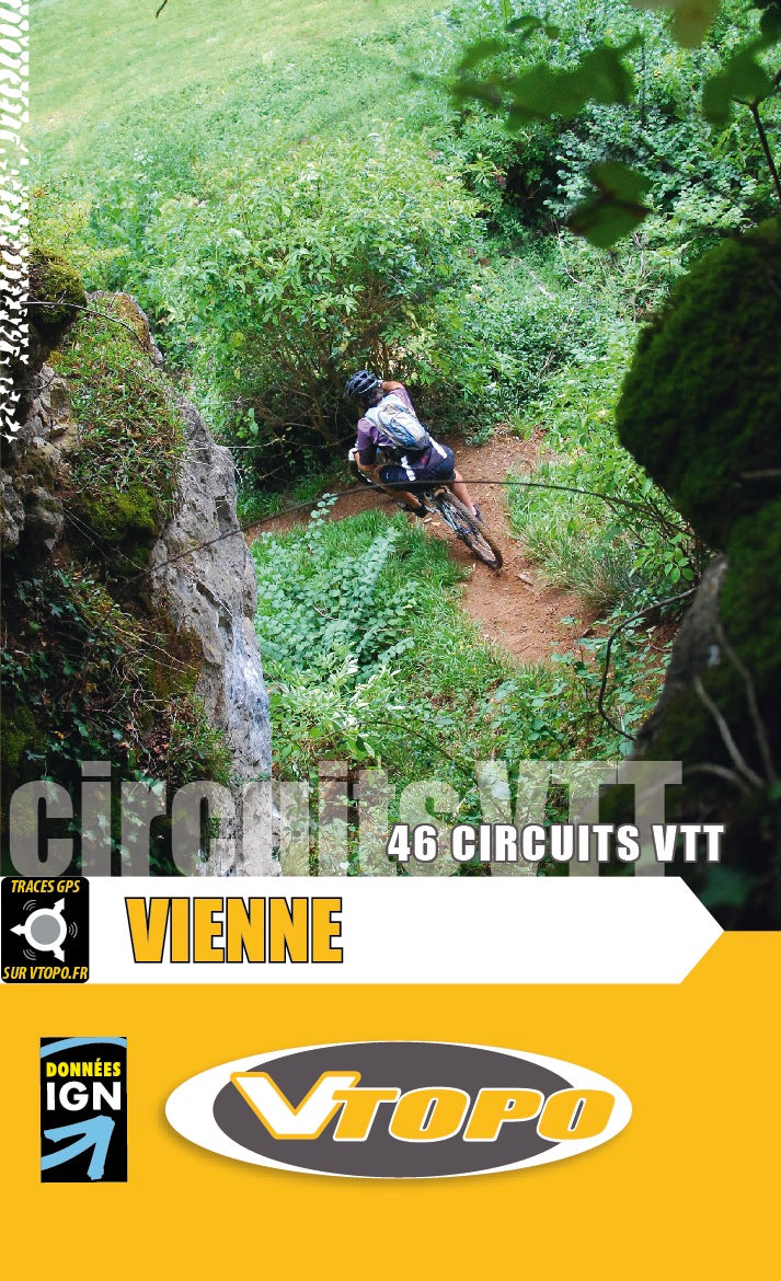
VTOPO MTB Vienna
VTOPO MTB Vienna
VTOPO MTB Vienna
VTOPO MTB Vienna
VTOPO MTB Vienna
VTOPO MTB Vienna

VTOPO MTB Vienna

Regular price$33.00
/
Shipping calculated at checkout.
Option
  • In stock, ready to ship
  • Inventory on the way

  • Itinéraires adaptés à la pratique du VTTAE (VTT à Assistance Éléctrique)
  • Papier écologique, label Imprim’Vert
  • Poitiers, Vonne, Vienna, Gartempe, Ch Telleraudais, and Freeride

By browsing this VTOPO, you will discover 46 mountain bike proposals for everyone, from family outings to freeriding and cross-country hiking, through the center of the Vienne department from west to east: Poitiers and its agglomeration, Lusignan , Vivonne, Châtellerault, Chauvigny and St-Savin, Angles-sur-L'Anglin… You will also find information on setting off, an orienteering hike and an urban approach to mountain biking. Everything is offered with a maximum of variants and combinations to compose à la carte outings.

With clear and detailed data, precise maps, useful information and quality photos, the VTOPO becomes the essential reference to enjoy 100% of these massifs. Finally, all circuits are evaluated using a relevant rating system ranging from V1 to V6.

  • A practical information booklet: region, point of view, services, heritage...

Vienna

Vienne is largely known for its famous amusement park, Futuroscope, which is one of the most important tourist and economic centers of the department. The regional capital, Poitiers, is at the heart of Vienne. It is a city steeped in history at the gates of the countryside. Its geography makes it a small hill by the river where many paths allow you to quickly go by mountain bike to less urbanized areas.
It is a country of history and heritage. All eras come together, from the Gallo-Roman site of Sanxay to the contemporary constructions of Futuroscope, passing through many sites, each more remarkable than the next: Saint-Savin, Chauvigny, Poitiers, Montmorillon, Sanxay...
The bicycle, silent, fast, non-polluting and fun, is an ideal tool for discovering this land and its history. The abundance of forests and the extensive network of paths are ideal for mountain biking. The fun paths in the forest, and our heritage, allow you to forget that this country is not very hilly. One of the challenges of this guide was to combine real mountain biking with a discovery of these many historical sites.

The cutting

This VTOPO is devoted to the center of the Vienne department from west to east. It offers more than 800 km of mountain bike routes. The north and south of the Vienne are only slightly covered in this guide.

This VTOPO is divided into 6 parts. The division is organized around certain rivers of the department (Vonne, Gartempe and Vienne) and around the 2 main cities of Vienne (Poitiers and Châtellerault). The purpose of this particular distribution is to make it easy to identify and organize hikes.
The first 2 parts are devoted to hikes in and around Poitiers (16 proposals in the Poitevine area). The third covers the banks of the Vonne between Sanxay, Lusignan and Vivonne (5 hikes south-west of Poitiers). The fourth is devoted to the south-east of the department on the banks of the Vienne and the Gartempe (15 hikes to Chauvigny, St-Savin, Lussac-les-châteaux, Montmorillon, Angles-sur-l'Anglin). The fifth part is dedicated to loops around Châtellerault (6 hikes to Thuré, St-Cyr, Vouneuil-sur-Vienne and Bonneuil-Matours). A sixth part offers an approach to some local freeride possibilities.

  • Pays : France
  • Région(s) : Center-Val de Loire
  • Département(s) : Vienna
  • 46 circuits détaillés avec cartes IGN
  • Format pratique 14 x 23 cm et léger 400 g
  • Traces GPS au format GPX compatibles App smartphones et GPS portables
  • Des infos récurrentes très utiles : variantes, région, point de vue...
  • Avec le système de cotation technique VTOPO de V1 à V6
  • 144 pages en couleur
  • Photos
  • Langue(s) : French
  • Auteur(s) : Alexis Mazoyer
  • ISBN : 9782916972411
  • Date de parution : July 1, 2012

Free delivery from 60€ in metropolitan France, Andorra and Moncaco.

Shipped within 48 hours.

A link to download your GPS Tracks will be sent to you by e-mail.

The GPS Tracks are complementary to the content of the VTOPO topo-guide.

We do not recommend that you only use the GPS Tracks without consulting the topo-guide in question.

With the latter, you will have access to difficulty levels , recommendations, precautions and a detailed description, useful in the event of an orientation error. You will also be able to view variants and other possibilities.

This site is protected by reCAPTCHA and the Google Privacy Policy and Terms of Service apply.

You might also discover


Recently viewed